
SARCTRAC Mk1
Satellite Antenna Rotator Controller and TRACker - Discontinued
SARCTRAC Mk1 is no longer available as a DIY kit. We do not provide separate SARCTRAC software.
SARCTRAC Mk1 is a portable, integrated, satellite tracking system, available only as a kit. SARCTRAC was developed so that students at our School Amateur Radio Clubs can have fun and learn about Low Earth Orbiting satellites during our lunchtime sessions. To make friends with a satellite you first have to know when and where it will be; point a small, directional antenna at it and use an Amateur Radio transceiver to listen or talk to it. It is a bit like fishing in the sky and just as challenging. It is really exciting when the kids hear their first satellite and then realise where it is. They always ask. “Can we talk to it?” We say. “Of course, you can.” But the reality is that satellites move so fast that their position and radio frequency is constantly changing. Tracking a satellite by hand, while trying to tune an Amateur Radio transceiver for a typical 10-minute overhead pass, is a real chore for kids. Setting up an automatic tracking system, with a commercial antenna rotator and all the computers, cables and programs needed, is both tricky and expensive. So, we made SARCTRAC quick and easy for the kids to set up and now it does all the work for them. SARCTRAC helps kids spend more time listening to signals from space, receiving data or pictures and even communicating with others via satellites. School kids in space? No problems!
What is SARCTRAC?
- It is a little box which does all the satellite tracking, antenna steering and Amateur Radio transceiver (rig) control automatically, so that students can just enjoy working satellites!
- It is best suited to portable operation, mounted on a sturdy tripod and attached to a small, hand-held, dual-band, satellite antenna. It can be quickly set up in a school playground and runs off batteries (it has reverse-polarity protection) or the same power supply (12-15VDC) as the rig. Best of all, it is self-contained in a small 125x85x55mm (5.0x3.3x2.2inch) weather-resistant enclosure.
- It does not require any on-site calibration or levelling: A one-time, 3D sensor calibration is all that is required. It automatically repositions the antenna even if the tripod is moved! It has been successfully used in playgrounds, in the bush, on mountain tops and even on the deck of a pitching and rolling ship!
- It has a built-in WiFi web server so students can control it via a web browser on their Mobile Devices or on a Personal Computer (PC) in the classroom. It allows students to select which satellites they want to track from a list of available satellites. It displays the system status and the next pass time, azimuth and maximum elevation of the selected satellite.
- It automatically schedules the tracking of each selected satellite in turn. It uses the latest orbital-prediction models to accurately track the selected satellites. It sounds an alarm at Acquisition Of Signal (AOS) and Loss Of Signal (LOS) before moving or re-positioning the antenna. It even automatically unwinds the antenna cables if they get wrapped around the tripod.
- It automatically controls the frequency and mode of an Amateur Radio transceiver. It compensates for the Doppler effect on the frequency of fast-moving satellites. It has a built-in satellite transponder/beacon database to set the correct frequency and mode of the rig. It connects to the popular Yaesu FT-817/818/857/897, all-band, all-mode, transceiver via a Yaesu CT-62 USB cable. It even has a TUNING page for manual frequency and mode changes.
- It automatically connects to the Internet via an access point such as a home WiFi router or personal hotspot on a Mobile Device. It automatically gets the network time and downloads the latest satellite orbital elements from the Internet.
- It uses a 3D Magnetometer/Accelerometer Sensor to detect the position of the antenna and two, geared DC motors, one for Azimuth (AZ) and one for Elevation (EL), to point the antenna at the selected satellite. The sensor and motors work in a stabilized, closed-loop control system.
- It has a built-in GPS receiver to get accurate time (if the Internet is unavailable) and location information. It starts up quickly using the last known position until a better GPS fix is available. It displays the local time when started and the street address of the current location. It uses a built-in World Magnetic Model to get the Earth’s local magnetic inclination and declination so it can convert between magnetic and true compass directions.
- It can be configured, updated and backed-up using a plug-in USB Disk. Update files can be downloaded from the Internet and copied to the USB Disk using any personal computer. They load automatically when the USB Disk is plugged into SARCTRAC and the power is switched on
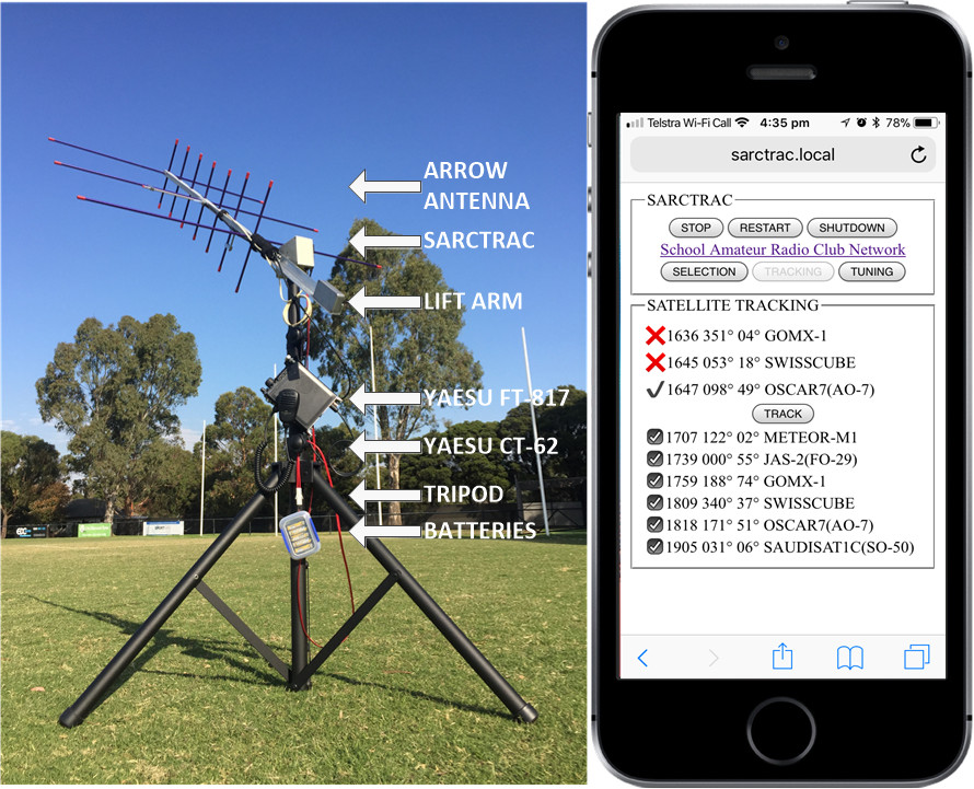
SARCTRAC Mk1 Portable Setup and Tracking Page
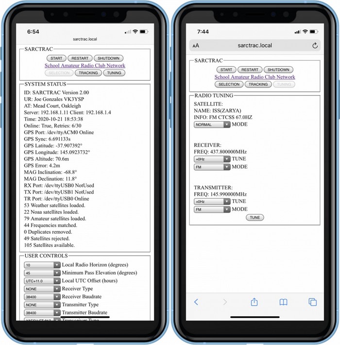
SARCTRAC Mk1 SELECTION Page and TUNING Page

SARCTRAC Mk1 SELECTION Page
History
We first introduced our free, Arduino-based, "Mini Satellite-Antenna Rotator" in 2015. It was a great success, with over 1100 radio enthusiasts from around the world building one. Unfortunately, sourcing the correct components, compiling and uploading the software and calibrating the sensor was too much for many who attempted building it. Let alone the pitfalls of setting up and using third-party, satellite-tracking software. And, as much as we love helping our readers out, we realised that we were spending more time supporting them than developing new projects for the kids.
We partly solved that problem by designing an integrated satellite tracking system that just works: SARCTRAC Mk1 took us over 15 months to develop and was the second generation of our 3D-Sensor based antenna rotator. It was half the size of the original unit with many new features. SARCTRAC Mk1 was offered as a DIY kit with all the parts and software required. Unfortunately, it only supported one type of radio: The Yaesu FT-817 and was only suitable for the experienced builder. So, we were still confronted with a large support effort.
Features
Setup
- Tripod-mounted for portable operation and quick set-up - Easily splits into two separate pieces: Tripod/rotator and antenna/lift-arm.
- DC powered for battery or solar operation - Typically uses the same power source as the radio.
- Integrated rotator and controller in one unit - Smaller with less cables. No third-party tracking software to wrestle with.
- Weather proofing possible - IP68 sensor and IP65 case with neoprene O-ring motor shaft seals. DIY seal around connectors with silicone sealant.
Networking
- WiFi enabled - Works with home WiFi network or WiFi-enabled mobile device with personal hotspot and broadband Internet connection.
- Internet enabled - Automatically downloads date, time and satellite orbital elements from the Internet.
- WiFi enabled mobile device used for control and display - No cables to separate PC or laptop.
- Built-in web server accessible by any web browser on the WiFi network - No tracking applications to install and configure.
Start-up
- Displays satellite SELECTION, satellite TRACKING and radio TUNING web pages - Logically organised pages.
- Start-up alert tones - Warn of disconnected USB CAT Cable, GPS or 3D Sensor.
- Access to START/STOP, RESTART and SHUTDOWN buttons on each web page - Important for rotator safety and tracker control.
- Starts with motors stopped - Operator action is required to start motors after power up for safety.
- Displays Local Time with Time Zone selection - Easier for scheduling.
- Date and time information provided by built-in GPS receiver or Internet time source - No clock setting required.
- Latitude and Longitude information provided by built-in GPS receiver - No station location entry required.
- Uses last saved location until GPS is available - Quicker startup.
- Stops polling GPS when location error is minimised - Reduces processor load.
- Displays reverse geocode address lookup - Confirms that the correct latitude and longitude is used.
- Antenna pointing information provided by boom-mounted 3D Sensor (magnetometer/accelerometer) - No compass calibration or levelling required.
- Magnetic inclination and declination information provided by built-in World Magnetic Model - No online searching for local magnetic offsets.
- Satellite orbital element information updated from Internet each day - No manual download required.
- Satellite position determined from the latest SGP4 orbital predication models - More accurate tracking.
- Uses last saved satellite selection - Quicker startup.
Satellite Selection
- Access to thousands of satellite orbital elements over the Internet - Distributed by Dr. T.S. Kelso at www.celestrak.com since 1985.
- Permits user-entry of selected orbital element library URLs - Select which satellite libraries are of interest.
- Each orbital element library contains hundreds of satellites in different categories, like weather, cube-sats, amateur and NOAA - Select only the categories you want.
- Permits loading of user-defined orbital element library files - Load pre-launch or unlisted orbital elements.
- Permits user entry of satellite names to be rejected - Omit whole series of unwanted satellites from the satellite selection list.
- Displays satellite statistics: Number of each type loaded, duplicates removed, number rejected and the total available - Helps manage your satellite database.
Satellite Tracking
- Tracks only selected satellites - Schedules tracking of each satellite in turn.
- Selected satellites displayed in order of their Acquisition Of Signal (AOS) time - Provides a next pass schedule.
- Visible satellites displayed in order of Loss Of Signal (LOS) time - Provides a best pass schedule.
- Displays next-pass, AOS time, azimuth and max elevation for each selected satellite - Easy to decide which satellite passes to track.
- Displays currently tracked satellite azimuth, current elevation and LOS time - Easy to compare current satellite LOS time with next satellite AOS time.
- Automatically points the antenna at a visible satellite - No manual antenna steering required.
- Built-in 3-second alert tone indicates immanent antenna movement - Safer operation. Alerts at the start and end of the current pass.
- Intelligent search algorithm selects the best visible satellite to track - Only tracks the longest passes.
- Permits selection of any one of multiple visible satellites - Compare and select the best of the currently visible passes.
- Automatically re-positions antenna ready for the next pass - No waiting at the start of each pass.
- Intelligent anti-windup algorithm - Unwinds the cables in between passes.
- Tracks multiple selected satellites in turn - No resetting selections between passes.
Radio Control
- Radio CAT control enabled - Automatically controls the radio frequencies and modes.
- Automatically controls the radio frequencies correcting for satellite Doppler shift - Accurate frequency control.
- Satellite beacon/transponder frequency and mode information provided by built-in satellite database - No online searching for satellite data.
- Permits selection of known satellite beacons or transponders - Useful to check the beacon frequency if the transponder is not heard.
- Permits manual adjustment of transmit and receive frequencies and modes - Useful to avoid interference and use the transponder bandwidth more efficiently.
Sensor Calibration
- One-Time 3D Sensor calibration required - Recalibration not usually required.
- Provides manual Start, Abort and Save calibration controls with tone feedback - Easier and more accurate calibration.
Miscellaneous
- Low Radio Frequency Interference (as compared with Arduino and Raspberry Pi 3) - Easier to hear selected satellites.
- DC reverse polarity protection - Setup at night with no more smoke and tears.
- Low power consumption - Runs 8 hours on 2Ah battery.
- Stall resistant motors and gearboxes with all metal gears - Safer operation with longer lasting gearboxes and no stripped gears.
Links
SARCTRAC Mk 1 - Discontinued
SARCTRAC Mk1 is no longer available as a DIY project. We do not provide separate SARCTRAC software.SARCTRAC Mk1 Manual (59 Pages, 4.5MB, PDF) Note: No longer available as a DIY project. SARCTRAC Mk1 Modification Procedure (For SARCTRAC Mk1, Version 1) SARCTRAC Mk1 in the Bush Video Kicking goals with SARCTRAC Mk1 Video SARCTRAC Mk1 just keeps tracking all day Video Demonstrating Amateur Radio Satellite Tracking with SARCTRAC Mk1 Video SARCTRAC Mk1 FT-817 Video (Showing how the FT-817 responds to fixed 1kHz steps with TX/RX VFO Switching) SARCTRAC Mk1 3D Sensor Calibration Video Note: The SARCTRAC Mk2 3D Sensor is now pre-calibrated.
Specifications
- Enclosure Size: 125x85x55mm (5.0x3.3x2.2inch)
- Operating voltage (typical): 12-15VDC
- Operating current (typical): 300mA
- Startup time (max seconds): 60
- Antenna rotation speed (max): 0.6 RPM azimuth and elevation
- Supported WiFi Network: 2.4GHz (IEEE 802.11bg)
- Supported Amateur Radios: Yaesu FT-817/818/857/897
- Supported USB CAT Cables: Yaesu CT-62 (Genuine FTDI Chip)
- Sensor cable length: 1m
- Power cable length: 1m
Safety
Please read the following very carefully. We accept no responsibility or liability for the following:
- This is a DIY project for the experience builder. We are not responsible for your time, costs, tools, availability or substitution of parts.
- Beware of moving parts - Unit may move at any time without warning. Do not stand or permit anyone to stand in the vicinity of the operating unit.
- Beware of eye hazard - Moving satellite antennas are prickly. Eye protection is recommended.
- Beware of pinch hazard - Keep fingers away from moving parts.
- Beware of electromagnetic radiation hazard - Do not use with high power transmitters. Recommend 10 Watts maximum.
- Beware of electrocution hazard - Do not use near power lines.
- Beware of lightning hazard - Do not use in thunderstorms, rainy or windy conditions.
- Beware of fire hazard - The unit has no built-in over-voltage or over-current protection.
- Not suitable for unattended operation.
- Not suitable for fixed or permanent outdoor operation.
- Automatically connects to the Internet: Adult permission and charges may apply.
- Constant adult supervision of the operation is required to prevent injury, especially around children.
- Constant adult supervision of the operation is required to prevent damage to the unit, anything attached to the unit or anything in the vicinity of the unit.
- Constant adult supervision of the operation of radio transmitters is required at all times. You must check your licence conditions and operating frequency.
- Document Version 1.14 for Hardware Version 2 and Software Version 1.03 Page 8
- Antenna, tripod, lift arm, mountings, cables or anything in the vicinity of the unit may be damaged under normal operation or due to software malfunction.
- The motors a light-duty: Do not force them. Avoid striping the metal gears.
- Installation of a safety DC cut-off switch is recommended.
Safety Testing
We have conducted the following safety testing of the completed product:
- Motor stall: The motors do not overheat or draw excessive current under continuous, full-power, stalled conditions.
- Antenna impact: The Arrow™ Antenna elements were not damaged under full-power impact with stationary objects or under continuous, restraint conditions.
- Human impact: The human operator was not damaged under full-power impact with the antenna. Note: Eye damage could occur even when the antenna is motionless.
Regulatory Compliance
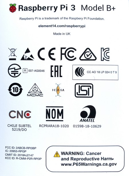
- SARCTRAC is essentially an embedded Raspberry Pi Zero W (RPi0) computer. The declarations of conformity, including local and regional approval certificates for the RPi0 can be found here. This covers: USA, Argentina, Australia, Bolivia, Brazil, Canada, Chile, China, Colombia, Costa Rica, Dominican Republic, Ethiopia, Ecuador, Guatemala, Hong Kong, India, Israel, Japan, Kenya, Malaysia, Mexico, New Zealand, Nicaragua, Panama, Peru, Philippines, Russia, Rwanda, Serbia, Singapore, South Africa, South Korea, Taiwan, Tanzania, Thailand, Turkey, Uganda, Uruguay and Venezuela. The RPi regulatory compliance marks are shown in the figure.
- SARCTRAC has a technical folder, which indicates it comprises an RPi0 together with additional electronic components and assemblies such as small motors, drivers, sensors and USB devices.
- SARCTRAC operates on 12-15VDC @ 1A and complies with Separated Extra Low Voltage (SELV) device requirements.
- SARCTRAC has been assembled with lead-free components and solder and complies with Restriction of Hazardous Substances (RoHS) requirements.
- SARCTRAC uses an RPi0, which has been tested to meet international RFI/EMC requirements. SARCTRAC uses additional sensors, drivers and motors, which due to their nature and operating conditions would not affect this base RFI/EMC qualification. In fact, the reduction of RFI to nearby receivers and EMC with nearby transmitters, to levels well below international standards, was a key design requirement of this product.
- SARCTRAC introduces additional safety risks, which have been fully identified above. Some operational safety testing has been carried out to qualify the safety risks as minor. The additional safety risks have been reduced, by design, to as low as is reasonably practicable.
Limitations
- Suitable for rotating only a single, small directional antenna (e.g. A handheld, dual-band, Yagi antenna such as an Arrow antenna) using a counterbalanced lift arm.
- Currently only suitable for controlling the Yaesu FT-817, All-band, All-mode, radio transceiver at this time. Others types to be advised.
- Performance may become sluggish if more than ten (10) satellites are actively selected for tracking.
- Unit will oscillate unless solidly mounted only on a rigid stand, such as a heavy-duty (speaker) tripod.
- Any formatting or data errors in the configuration files will stop the operation of the unit. Always keep a backup of the working configuration files.
- Oscillates between start azimuth points if predicted passes have the same AOS time in minutes
- Displays predicted passes even with zero degrees maximum elevation
- Web pages are static: Track button must be re-pressed to refresh correct tracking status