MTG004 - High Altitude Balloon
This project is a High Altitude Balloon (HAB) carrying an Amateur Radio payload which can be tracked for thousands of kilometres.
Codenamed "MTG004", it comprises a low power (50mW), HF MFSK payload, designed to be sent aloft by a helium-filled, latex weather balloon.

MTG004 Payload

MTG004 Launch

MTG004 Recovery
MTG004 Flight Planning

Balloon, Parachute, Rigging and Payload

High Altitude Balloon Flight Profile from Release to Recovery
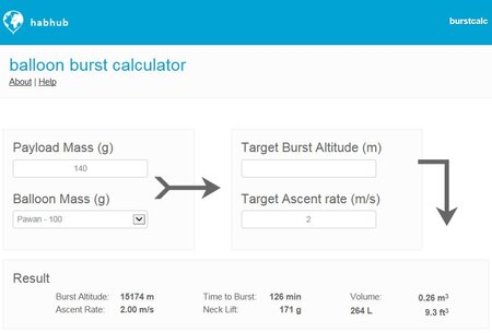
Balloon Burst Altitude and Ascent Rate Calculator
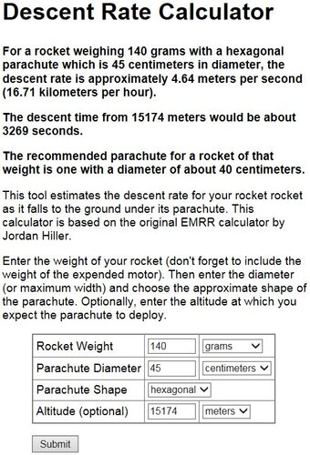
Parachute Decent Rate Calculator

Balloon Flight Predictor
MTG004 Payload

MTG004 Payload Assembly

MTG004 Payload Pictorial Schematic

MTG004 Power Amplifier / Low Pass Filter Assembly

MTG004 Sensor Board Assembly

MTG004 Software Processing Data Flow Diagram
MTG004 Design Notes

MTG004 GPS-Synchronized Clock

MTG004 Power Amplifier / Low Pass Filter Simulation
MTG004 Flight Data
- Flight Name: “MTG004”
- Payload Name: “Screwball 1”
- Operational Frequency and Modes:
- 10.139250MHz JT65 USB
- 10.139750MHz JT9 USB
- Alternating every minute: JT65/JT9. Telemetry Only.
- Telemetry format:
- Two line 13-Character, Base32-Encoded messages. 10 minute sequence.
- Message 1: Sent on minutes 0 and 5
- Callsign, Internal Temp, Number of Satellites in View, Battery Voltage
- Message 2: Sent on minutes 1, 2, 3, 4, 6, 7, 8, 9
- Latitude, Longitude, Altitude
MTG004 Hardware Data
- MTG004 Configuration
- Balloon – Pawan 100 latex weather balloon
- Balloon diameter 1.6m
- Balloon weight 100g
- Parachute – Estes 2267 Model Rocket 18 Inch Parachute
- Parachute diameter 45cm
- Payload – Spotlight 120mm Styrofoam Ball
- Payload weight 120g
- Other weight 60g
- MTG004 Payload
- GPS Antenna – 1.5GHz Quadrifilar Helix
- GPS Receiver – uBLOX NEO-6MV2
- Controller - Arduino Pro Micro ATmega32U4 5V 16MHz
- DDS VFO - AD9850
- 30m PA/LPF - BS170
- Voltage/Temperature Sensor Board – LM35
- 5V LDO Regulator – LM2940CT-5.0
- Batteries – 4 x Energizer Lithium Ultimate AA
MTG004 JT65 Data
NSPSEC = 11025 Number of samples per secondNSPSYM = 4096 Number of samples per symbolNSPS = NSPSEC / NSPSYM = 2.7Hz Number of symbols per secondNSYN = 63 Number of sync symbolsNSYM = 126 Total number of symbolsTSYM = 1 / NSPS = 372ms Symbol periodTGAP = 60000 - NSYM * TSYM = 13128ms Transmission gap each minute
MTG004 JT9 Data
NSPSEC = 12000 Number of samples per secondNSPSYM = 6912 Number of samples per symbolNSPS = NSPSEC / NSPSYM = 1.7Hz Number of symbols per secondNSYN = 16 Number of sync symbolsNSYM = 85 Total number of symbolsTSYM = 1 / NSPS = 576ms Symbol periodTGAP = 60000 - NSYM * TSYM = 11040ms Transmission gap each minute
MTG004 Decoding GPS NMEA Sentences
The GPS receiver provides the following data every second at 9600bps:
$GPRMC,101059.00,A,3754.45031,S,14505.53645,E,0.016,,030315,,,A*60$GPVTG,,T,,M,0.016,N,0.029,K,A*2F$GPGGA,101059.00,3754.45031,S,14505.53645,E,1,09,1.19,78.5,M,-1.9,M,,*60$GPGSA,A,3,32,22,18,27,04,19,24,11,14,,,,2.11,1.19,1.74*09$GPGSV,3,1,11,01,06,227,,04,33,228,36,11,22,228,36,14,79,019,36*79$GPGSV,3,2,11,18,28,106,31,19,44,272,37,21,10,048,21,22,62,136,40*7C$GPGSV,3,3,11,24,15,132,23,27,37,315,29,32,27,264,26*47$GPGLL,3754.45031,S,14505.53645,E,101059.00,A,A*7A

MTG004 Antenna Simulation
MTG004 Telemetry
Telemetry was received from the High Altitude Balloon payload on 10.138MHz via a mobile HF antenna and transceiver (ICOM IC-7200) in the chase car. The recovered audio was sampled by a USB sound-card on a Windows laptop computer. The WSJT-X application, by Dr. Joe Taylor K1JT, was used to decode both the JT9 and JT65 telemetry messages. The Waterfall Window shows the 65-tone and 9-tone signals in the pass-band of the receiver. A blue indicator, at 1700Hz, configured the application for decoding JT65 below and JT9 above. The Decoder Window shows the history of decoded messages, received every minute. The # symbol indicates JT65, while the @ symbol indicates JT9. WSJT-X returned all decoded messages in a file named ALL.TXT. A purpose-built, Visual Basic Application, named HABLINK, was used to monitor and read the decoded message file, read the chase car's GPS location, create and upload Listener Information, Listener Telemetry and Payload Telemetry JSON documents in UKHAS format to the HABITAT database, via a mobile 3G Internet connection. The resulting map plot of the HAB flight could then be viewed by eveyone on the HABHUB website.

WSJT-X Waterfall Window

WSJT-X Decoder Window

HABLINK Window
MTG004 Flight Profile
Flight Results:
Flight Distance: 172km
Flight Time: 2 hours 13 minutes
Maximum Altitude: 20km
Maximum Internal Temperature: 53.6°C
Minimum Internal Temperature: 2.9°C
Ascent Rate: ~3m/s
Decent Rate: ~ 9m/S

MTG004 Flight Track on HABHUB
References
- Melbourne Amateur Radio and Technology Group - Global Space Balloon Challenge
- GippsTech 2015 High Altitude Balloon Presentation
- Please note that under section 115 of the Australian Environment Protection Act 2017, it is now illegal to launch balloons into the environment, even for scientific and educational reasons, without approval.