
Search and Rescue
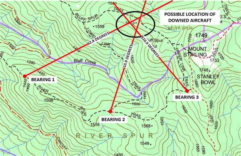
Imagine that a downed aircraft has activated an emergency homing beacon after crashing in rough terrain. You are the radio operator with the search and rescue squad travelling along the River Spur Trail. You regularly radio in your position to the rescue communications centre. Using your tracker, you have taken three compass bearings and plotted them on the map below. By observing where the lines intersect you figure the location of the beacon: An unnamed peak at 1613 metres, not far from Bluff Spur hut. You radio in the position of the crash site: A rescue helicopter is on its way by the time you arrive.

Introduction
Direction Finding can be used for triangulating the location of an emergency homing beacon. You simply take several compass bearings using your tracker at three different positions and then plot them on a map. The intersection of the three bearing lines forms a triangle indicating the possible location of the beacon. Amateur Radio Direction Finding (ARDF) has become a popular sport of sorts. This mission will give you a taste of it and hone your skills.
Preparation
You will need:
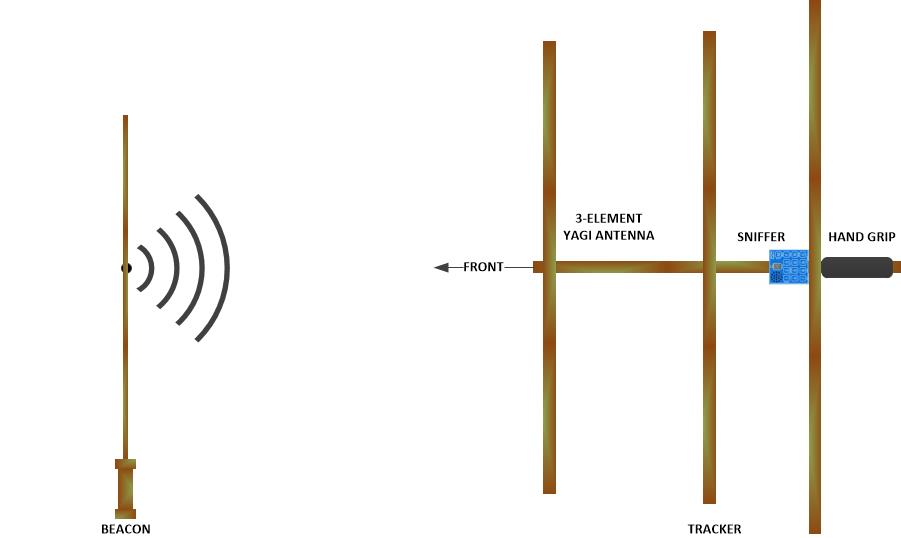
- ARDF tracker (We use a tape measure Yagi and VK3YNG sniffer http://www.foxhunt.com.au/)
- ARDF beacon (We use the Byonics Micro-Fox http://www.byonics.com/mf)
- Map (We use a Google satellite map of the area with overlaid grid squares printed on A3 paper and laminated)
- Compass (We use the iPhone app)
- Fine whiteboard marker pens
Activity
The tracker looks like a small TV antenna with a little box called a “sniffer”. The sniffer lets you hear the beacon’s signal. To find the beacon:
- Hold the rear end of the tracker by the hand grip with the elements pointing up and down.
- Observe the number displayed on the sniffer (0 – 9) and listen to the pitch of the tone from the speaker as you move the tracker around.
- Turn in a complete circle: The highest number displayed together with the highest tone pitch indicates that the tracker is pointing towards the beacon. The number increases as you get closer to the beacon and the tone is reset to a lower pitch each time the number increases.
- Move the tracker slowly from left to right and back again in the general direction of the beacon.
- Note where the tracker is pointing for the highest number and pitch. Use landmarks or take a compass bearing and draw a line from your position in that direction on a map.
- Move along the designated trail to a different position and let someone else get a bearing for the map.
- At the end of the trail your map will show where the plane is and you can complete your mission.
Homework